What did you do today!?
|
|||||||||||||||||||||||
| platetectonicsearthquakeandvolcanoplotlab[1].pdf |


HOMEWORK: eXPLAIN THE MIND MAP TO A MEMBER OF YOUR HOUSEHOLD. rECORD AN AUDIO FILE (WITH YOUR PHONE) AND BRING IT TO THE NEXT CLASS -tHURSDAY AND PLAY IT TO YOUR PARTNER
0 Comments
What did you do today!?
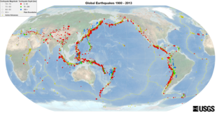
1. We introduced "The Ring of Fire" -5 minutes (explain this definition to your partner)
The Ring of Fire, also referred to as the Circum-Pacific Belt, is a path along the Pacific Ocean characterized by active volcanoes and frequent earthquakes. The majority of Earth’s volcanoes and earthquakes take place along the Ring of Fire
2. You reviewed the Earth's Crustal Plates and discussed the occurrence of tectonic activities along these boundaries. You watched a video on the Ring of Fire. 8 minutes (After the video ASK YOUR PARTNER TWO QUESTIONS about it)
3. In groups, you were given one of the 6 Plate Boundaries. You were asked to draw a diagram and answer questions related to that plate boundary. You drew your diagrams on the board and presented to the class.
Today's Power Point Notes -CLICK HERE

| 6_plate_boundaries.pdf |
| plate_boundary_activity_key.pdf |
Homework:
What did you do today?
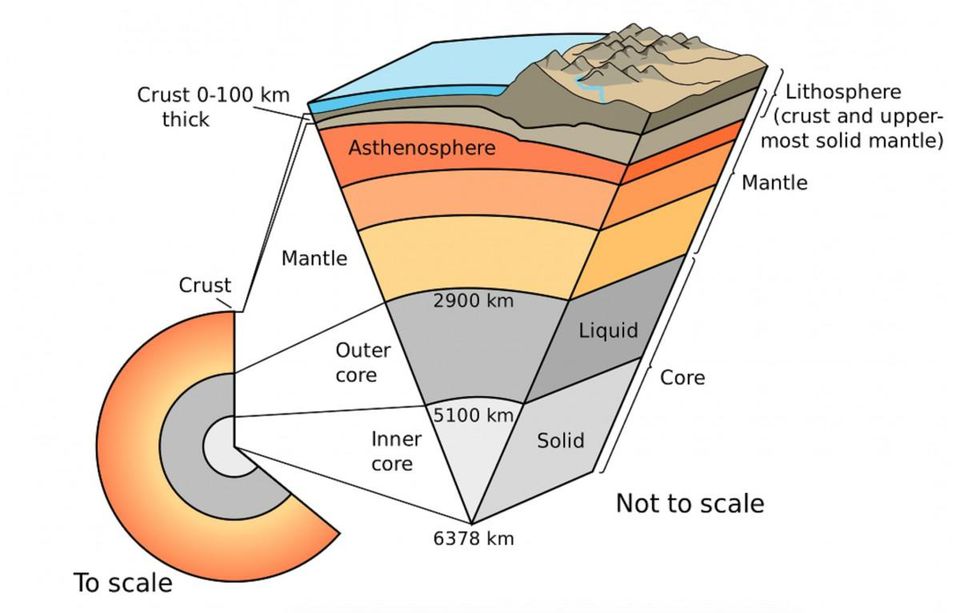
2. You talked about how formation of the earth led to the creation of a 'layered earth'
3. You watched a video clip talking about the formation of early earth.
4.You began reading pages 51-56 in Chapter 4 of textbook (see PDF file below)
5. You were asked to create your own diagram of the 'interior of the earth' (due.....)
Homework: 1. Interior of the Earth Diagram (Due....)
Reminder -Map of Central America ( Due...
Today's Notes: CLICK HERE
| planet_earth_chapter_4.pdf |
What did you do today!?
1. You created and handed in the Unit 1 MIND map (Geography Intro and Mapping)
2. You began to work on your second map = Central America and the Caribbean (see instructions below)
Central America and Caribbean Practice Quiz: CLICK HERE
| amcentrale06__1_.pdf |
HOMEWORK: The Central America and Caribbean Islands Map (Wed, Sep 30th midnight)

What did you do today?!
1. You discussed "Military Grid Reference Points" (in your mapping notes package)
2. You competed in the "Military Grid Treasure Hunt" -- winning teams won a bonus mark.
Homework: Study for the unit test (Monday) - look through all your Notes (mind Maps)
| map_and_military_grid_challenge.docx |
| grid_excersies.pdf |
What did you do today?!
1. We did a 5 questions mini Quiz on Schoology
2. We went over your homework with a partner (Pair Share)
1. You went outside an competed in the Mapstravaganza competition. Using military grid referencing you completed a scavenger hunt. Winning teams won a bonus mark.
Homework: None

What did you do today?!
2. you shared your work from the 'Latitude/Longitude worksheet' with a partner
3. You went through the first sections of your 'Map Skills Package' You looked at:
* Scale
* 6-digit grid reference points
Homework: 1. Finish your 5 themes ( pick a city outside of North America) graphic organizer
2. Finish Practice Questions (exercises) for Maps (p. 18-27) see Thursday/Friday class
Look through the Mind Map of today's lesson and explain it verbally to a member of your household
| mapping_skills1.pptx |
| topo_map_skills.pdf |
What did you do today?!
2. Two assignments were due: 1. Map of South america ( due Monday); 2. 5 Spheres photo hunt
3. You discussed finding surface areas for regular and irregular shapes on topographic maps. You completed the practice examples in your mapping package. Please see documents attached to the LESSON on Thursday September 12th -A student Questions package and a Presentation)
4, You were given the remaining time in class to complete the 2 topographic maps and questions at the end the end of your mapping notes package (due Tuesday) Please the Mapping package from Thursday September 12th lesson -scroll down to the two last topographic maps and questions
Homework: (1) Finish all of the questions in your Mapping Package (due Tuesday) (2) Study for the Unit 1 test (on Thursday)
Unit 1 test will consist of:
5 spheres, 5 themes, Latitude/Longitude, Time Zones, 6 and 4 digit grid reference, Topographic map skills (from your package)

What did you do today?!
1. You wrote a 5 questions quiz on 5 Spheres ( created in Schoology)
2. You discussed the "5 themes of Geography" and learnt about the acronym MR.HELP (see attached notes)
3. With a partner, you applied the 5 themes of Geography to the city of Coquitlam. You then shared your responses with the class.
4. You completed practice Questions on p. 13-15 (Lesson 2) in the Geography practice Questions (see below)
5. You were asked to select a city, outside of North America, and apply the 5 themes of Geography to it using the graphic organizer provided.
Homework: 5 themes graphic organizer (due Friday)
TODAY"S NOTES
| 5themes.docx |
The Five Themes Power Point -CLICK HERE
The Geography practice Questions (pages 4-28) -USE it to complete pages 13-15 today
| geography_practice_sheets_for_students_p.4-28.pdf |
Archives
October 2020
September 2020
January 2020
December 2019
November 2019
October 2019
 RSS Feed
